


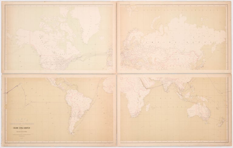
Carte des communications télégraphiques du Régime Extra-Européen dressée d'après des documents officiels par le Bureau international des Administrations télégraphiques.
Berne [Bern]: Bureau international des Administrations télégraphiques, 1882. Designed and engraved by Georg Christian von Hoven. Printed by Jakob Friedrich Ferdinand Lips. Vintage lithographic map. In four pieces, each mounted on cardboard. In four pieces. Item dimensions: 786 × 502 mm each. Map dimensions: 779 × 490 mm each. Maps slightly dusted and tanned. Cardboards chipped here and there. Two pieces rubbed towards the left edges with no effect on the print area. With the hand-drawn route of a journey around the world which took place between November 1883 and February 1885 with the path marked in blue pencil and the dates in black ink. Overall in fine condition.
Scarce, late nineteenth-century map of the World’s telegraph lines. Published by the Bureau international des Administrations télégraphique, it shows the global telegraph network of terrestrial and submarine lines during the year 1882, containing almost 2,000 network nodes with 2450 connections. An important document on the development of telecommunication.
A hand-drawn path on the map with dates written in ink also indicates the route of a journey around the world. Departing from Malmö in late 1883 it goes along the coasts of South America, crosses the Pacific Ocean to Japan, then indicates stops in China, Thailand and India to finally return to Europe through the Suez Canal in early 1885.
Extremely scarce, WorldCat locates only two copies in institutional holdings, one in The British Library and another one in the University and City Library of Cologne.
Literature: Wenzlhuemer, R.: Connecting the Nineteenth-Century World. The Telegraph and Globalization. New York: Cambridge University Press, 2013.
.
Price: €15,000.00