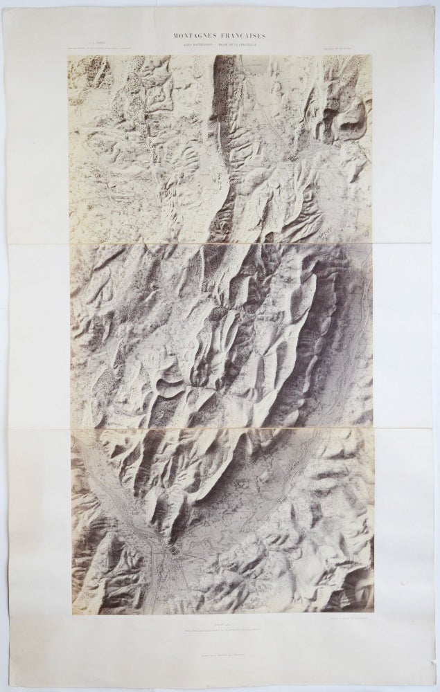
Montagnes Francaises. Alpes Dauphinoises — Massif de la Chartreuse. Feuille de Chambéry. Échelle 1/80000. Réduction photographique du plan-relief topographique.
Paris: Auguste-Rosalie Bisson, between 1864–1866. Vintage photographic map. Albumen print mounted on cardboard sheets, comprises three sections. Foldings strengthen with cloth. Item dimensions: 555 × 890 mm (in three parts). Photograph dimensions: 395 × 735 mm (in three parts). Cardboard and photograph moderately yellowed, with modest cockling — more visibly to the upper and lower sections. Small tear to the upper left part of the upper cardboard section and light water stains towards the left and bottom edge of the lower cardboard section, none affecting the photograph. Upper right corner slightly dog-eared. The photographs are in nearly fine condition. Overall in very good condition.
Scarce, nineteenth-century photographic map of the Dauphiné Alps, created by the French pioneer photographer, Auguste-Rosaline Bisson.
The original, hand-painted relief map which served as the basis of the present photographic map was made by Libre-Irmand Bardin (1794–1867), a former professor of the École Polytechnique in Paris who created a series of topographic maps of the most important French mountain ranges in 1864–1866. As such maps were expensive to produce and difficult to handle, Bardin commissioned Auguste-Rosaline Bisson (1826–1900) to make photographic reproductions of his maps in order to make them affordable for a larger audience. Thanks to his refined lighting, Bisson’s images represented the maps in an almost tactile manner achieving the praise of his contemporaries.
Auguste-Rosaline Bisson (or Bisson jeune) is most famous for being the first photographer to take photos from the summit of Mont Blanc. With 25 porters carrying his equipment, he climbed the mountain in July 1861 and took three images on large collodion plates. From the 1840s until 1863 he worked together with his brother, Louis-Auguste Bisson (1814–1876) whom with they run a truly successful photographic firm, employing about 200 people at the peak of their career. In the 1850s, the Bisson fréres “were known as one of the most important photographers not only in France, but in Europe as well.” (Hannavy, 2008) They were active in all genres of the medium, taking portraits, architectural, landscape and reproduction photographs. They met the Alsatian industrial and geologist, Daniel Dollfus-Ausset (1797–1870) in 1854 who commissioned them to take photographs of the Alps for his research on the glaciers. As a result, the Bisson brothers created a great number of remarkable images of the French, Swiss, German and Italian Alps. After their firm got bankrupt in 1863, mainly because of these expensive expeditions, August-Rosaline and Louis-August continued their career separately.
Extremely scarce, we could not trace any copy of this sheet of Bardin’s maps in institutional holding.
Bibl.: Dollfus-Asset, Daniel; Savy, F.: Matériaux pour L’étude des Glaciers par Dollfus-Asset. Paris: Libraire des Sociétés Géologique et Météorologique de France, 1868. 480–485 pp.; Hannavy, John: Encyclopedia of Nineteenth-Century Photography. Volume 1 A–I. New York: Routledge, 163 p.; LeBleu, M.: Rapport de M. LeBleu, ingénieur des mines, sur les plans en relief, présentés par M. BARDIN, à la Société industrielle de Mulhouse. – Séance du 27 Juin 1866. In: Bulletin de la Société Industrielle de Mulhouse. Mulhouse: Imprimiere de P. Baret, 1866. 387–394 pp.
.
Price: €2,500.00