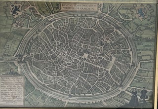
Brugae, Flandricarum Orbium Ornamenta.
Cologne: 1574 (?). 30 x 45 cm. More
Cologne: 1574 (?). 30 x 45 cm. More
In Bologna: presso Vittorio Benacci, 1601. Illustrated with two double-page engraved plates. Enriched with two recurring large woodcuts and woodcut and typographical head and tailpieces. First edition. In contemporary vellum. Coll: [𝜋]4; A–H4 ; [ 8], 64 p., and [2] engraved plates. One of the earliest reports of the decisive..... More
![Item #2578 [Extracted from:] [Recüeil de plusieurs relations et traitez singuliers et curieux.]...](https://foldvaribooks.cdn.bibliopolis.com/pictures/2578.jpg?width=320&height=427&fit=bounds&auto=webp&v=1644238468)
[Paris]: [1679]. Extracted from the first edition. In later paper wrappers. With the large map of Japan, engraved by Jean-Louis Durant. 72 p. and a large engraved map of Japan, size: ca. 78 × 55 cm. Tavernier’s Relation du Japon, with the scarce large map of Japan Carte des Isles..... More
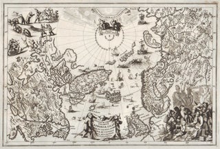
Munich: 1701 [i.e. 1703]. Copper-engraved map. Uncolored. Verso blank. From Heinrich Scherer’s Atlas Novus. 350 (394) × 230 (278) mm. An attractive map of the North Pole and adjacent land masses. An important milestone in the development of scientific and thematic cartography, providing remarkable and revolutionary alternative version of the..... More
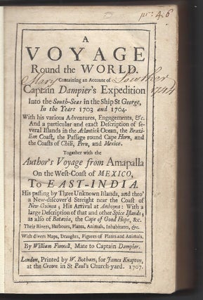
London: Printed by W. Botham, for James Knapton, at the Crown in St Paul’s Church’s Church-yard, 1707. First edition. In contemporary (publisher’s?) leather, panels blind-tooled, spine gilt. Rebacked, later endpapers. Printed bibliographical note mounted on front pastedown. [24] 300 [i.e., 302] [18] p., and 10 engraved plates and 5 folding..... More
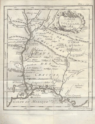
Paris: Chez Cl. J. B. Bauche, 1753. First edition. Duodecimo. In two volumes. In contemporary leather. Spine with five raised bands, gilt, each with red title vignettes. With marbled endpapers and fore-edge. (6), x, 261, (2) p. and 1 folding map of Louisiana and 5 plates; (4), 338 p. and..... More
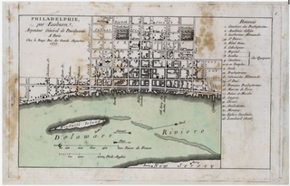
Paris: Le Rouge, (1777). Sticked on strong paper. Strong brown spots due to glue. "The interest in accurate information about Philadelphia was seemingly as great with the French as with the English. George Louis le Rouge, the royal geographer, published a small adaptation of the Clarkson-Biddle map in Paris, omitting..... More
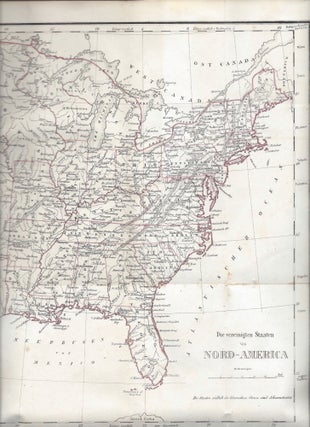
Frankenthal: im Verlage der Gegelischen Buchdruckerei und Buchhandlung, 1788. Second separate edition. With woodcut printer’s device on title page, and woodcut headpieces. In contemporary hard paper. (10), (1)–272 p., and 1 folding, engraved, hand-coloured map of North-America and Newfoundland (by Joseph Marianus after the 1783 Faden map). The first German..... More
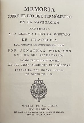
En Madrid: en Casa de la Viuda de D. Joaquin Ibarra, Año de MDCCLXXXXIV [1794]. First Spanish edition. Alain Gerbault’s copy, with his bookplate on the inner front panel. In later leather. Gilt edges. Panels with gilt frame, spine gilt. Marbled endpapers. I. [12 (last blank)] 21 [1 (blank)] p...... More
![Item #3099 [Caption title:] Catalogue des Globes, Sphères, Atlas, Cartes, et Autres Ouvrages,...](https://foldvaribooks.cdn.bibliopolis.com/pictures/3099.jpeg?width=320&height=427&fit=bounds&auto=webp&v=1698678532)
A Paris: Chez Delamarche, Géographe, rue Jardinet, no. 13, vis-à-vis celle de l’Éperon, 1806. First edition. Published unbound, papered spine. [3] 4–59 [1] p. carce catalogue and price list of the Delamache map publishing firm. An early 19th-century price catalogue of the Delamache map publishing firm, producer of globes..... More
![Item #1702 [A Brief History Of The Colony Of New Sweden.] De colonia Nova Svecia in Americam...](https://foldvaribooks.cdn.bibliopolis.com/pictures/1702.jpg?width=320&height=427&fit=bounds&auto=webp&v=1566981606)
Upsaliae [Uppsala]: Excudebant Regiae Academiae Typographi, [1825]. First edition. Text in Latin and Swedish. With an engraved, folding map of Delaware Bay and the colony of New Sweden. The gatherings bound together by sewing, otherwise unbound. (4), 34 p., and an engraved, folding map. First edition of Carl David Arfwedson’s..... More
![Item #1489 [Memoria relativa a la navegacion del Rio Tajo.] Memoria que tiene por objeto...](https://foldvaribooks.cdn.bibliopolis.com/pictures/1489.jpg?width=320&height=427&fit=bounds&auto=webp&v=1535555387)
Madrid: Imprenta de Don Miguel de Burgos, 1829. First edition. [Atlas imprint: A Paris: Imp. Lith. de Engelmann & Cie. Lithographes de la Chambre et du Cabinet du Roi, 1829. (10 [desultorily numbered, but complete]), 11–118 p.]. Text volume: In publisher’s illustrated wrappers. Atlas: In publisher’s printed wrappers. Lithographed throughout..... More
Leipzig: F. A. Brockhaus, 1847. First edition. In contemporary half leather. Spine with four raised bands, gilt ornaments and title. (6); (1)–317, (1) p., and a folding map, with hand coloured frontiers. A tale of German immigrant life in the lower Mississippi Valley with an accurate map of the United..... More
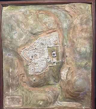
Edwin Smith: Sheffield, 1848. Topographic Model in a Wooden Case. 33X28cm. A large topographic plaster model of Jerusalem and the mountains surrounding it. The model is painted by hand and placed in a wooden case. At first, Edwin Smith made such models as an educational tool; however, before long, he..... More
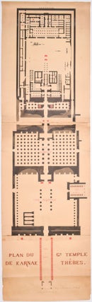
[France; Egypt?]: 1860s. Original, vintage hand-drawn and colored plan. Rolled. Large format, 4 sheets mounted together. Size: ca. 235 × 70 cm. Brune’s plan of the Great Temple at Karnak is the most detailed and precise 19th-century architectural plan of the monument. This large, exhibition size plan of..... More
![Item #2737 [Lebanon] Carte du Liban d'après les reconnaissances de la Brigade Topographique du...](https://foldvaribooks.cdn.bibliopolis.com/pictures/2737.jpg?width=320&height=427&fit=bounds&auto=webp&v=1660481180)
Paris: Imp. Lemercier, rue de Seine 57. (Gravée per Erhard Schièble rue Bonaparte 42), 1862. Color lithograph map in 16 sections mounted with linen. Bookseller’s vignette on verso (A. Corion Succ.r de H. Dorlin, Paris). 74 × 96.5 cm. First edition of the most important map in the history of..... More
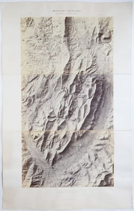
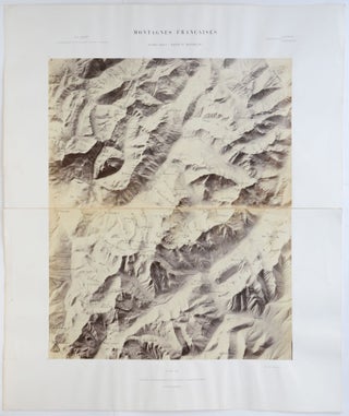
Paris: Auguste-Rosalie Bisson, between 1864–1866. Vintage photographic map. Albumen print mounted on cardboard sheets, comprises three sections. Foldings strengthen with cloth. Item dimensions: 555 × 890 mm (in three parts). Photograph dimensions: 395 × 735 mm (in three parts). Scarce, nineteenth-century photographic map of the Dauphiné Alps, created by the..... More
Paris: Auguste-Rosalie Bisson, around 1866. Vintage photographic map, with the names of the glaciers, peaks and altitude printed on the photograph in black. Albumen print mounted on cardboard sheets, comprises two sections. Folding strengthened with cloth. Item dimensions: 545 × 650 mm (in two parts). Photograph dimensions: 395 × 489..... More
![Item #1571 [Autograph Letter and Signed Photographic Portrait.] Mycenæ. A Narrative of...](https://foldvaribooks.cdn.bibliopolis.com/pictures/1571.jpg?width=320&height=427&fit=bounds&auto=webp&v=1555507212)
New York: Scribner, Armstrong & Company, 1878. First American edition. Association copy. With the graphical bookplate of Edmund Clarence Stedman on the front pastedown. With Schliemann’s one-page holograph letter in ink on blue paper (136 × 219 mm), together with a cut-out article, mounted on the verso of the frontispiece..... More
Berne [Bern]: Bureau international des Administrations télégraphiques, 1882. Designed and engraved by Georg Christian von Hoven. Printed by Jakob Friedrich Ferdinand Lips. Vintage lithographic map. In four pieces, each mounted on cardboard. In four pieces. Item dimensions: 786 × 502 mm each. Map dimensions: 779 × 490 mm each. Scarce..... More
London: Published at the Admiralty, under the Superintendence of Captain F. J. Evans, R. N : F. R. S : Hydrographer, Sold by J. D. Potter […] (Engraved by Edw.d Weller), [ca. 1892] 1st July 1875 (Large corrections July 1882. Nov.r 1892.). Engraved map. Scale [ca. 1:650 000]. With notes..... More
London: Published at the Admiralty, under the Superintendence of Captain W. J. L. Wharton, R. N : F. R. S : Hydrographer, Sold by J. D. Potter […] (Engraved by Davies & Company), 16th May 1892. First edition. Engraved map. Scale 1:12,093 (E 55°29'/S 4°37’). Size: ca. 100 × 70..... More
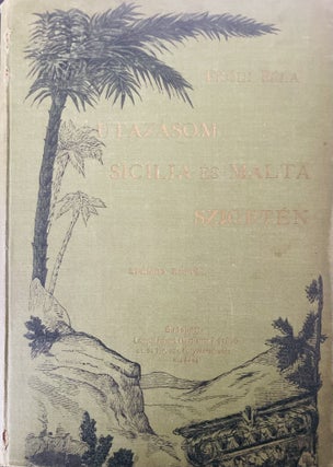
Budapest: Lampel, (1896). First edition. In original illustrated cloth. 8)+217+(3) p. A book by a Hungarian traveller about his trip in Sicilia and Malta. More
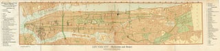
New York: From Jewish Encyclopedia, 1904. 106 x 25 cm. Shows the places of the Jewish institutions in the city: synagogues, cemeteries, schools in New York. More
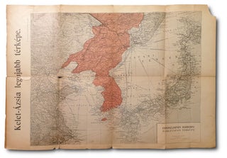
Budapest: Grünbaum, 1904. Map. 59x40 cm. More
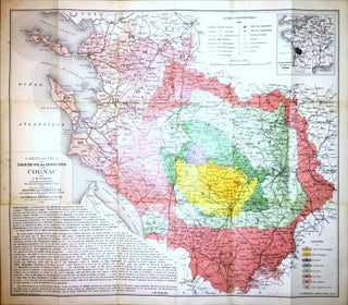
Paris: F. Champenois, Imprimeur-Éditeur (Gravé par A. Simon), (1909). First edition.With a mounted photographic advertisement of the Tesseron distillery at Châteauneuf-sur-Charente. In publisher’s folder. 720 × 620 mm. In May 1909 a very precise definition of the outer boundaries of the cognac region and the appellation control (appellation d'origine contrôlée)..... More
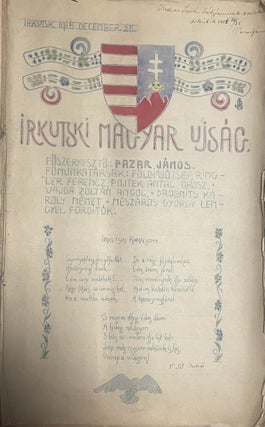
Irkutsk (Russia, Siberia): 1916 December 25. Published without binding. 59 pp. with one hand drawn map. Most of the book is handwritten. Title page hand colored. This unique newspaper was made by Hungarian prisoners of war in the POW camp at Irkutsk, Russia. Christmas issue with a selection of translations..... More
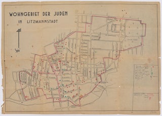
[Poland]: Early 1940s. Handwritten map of the Lodz ghetto with legend, marks and signs in red, green, and black ink, and pencil. Drawn on a contemporary German, mimeographed map, printed in black. Handwritten legend in Polish. 55 cm × 39 cm. Handwritten map of the Lodz Ghetto, drawn by a...... More
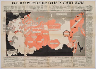
[Wlochy]: [S.n.], [1945]. Original, vintage map. Surrounding text in English. Printed in black and shades of red. 495 mm × 695 mm. The first appearance of a cold war map, documenting the Gulag, the Soviet concentration camp system. The map was created by Polish military offıcers, Sylvester Mora..... More
Budapest: Hermann Geibe, 1955. 19,8×28,3 cm. From: Prónay: Skizzen aus dem Volksleben in Ungarn. More
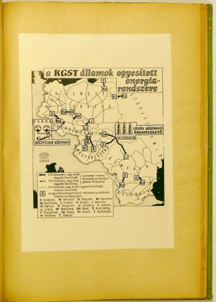
Budapest: ÁFTH /Állami Földmérési és Térképészeti Hivatal, 1963. In contemporary binding. 81 p (Include 71 map) Tyeped pages. A very interesting world political summary, illustrated with lots of maps, where they indicate what changes happened on the maps as a result of the events. It was probably made for internal..... More
![Item #147 Neue und Vollkom[m]ene Carten, des Königreich Bosnien, Sambt ihren darzugehörigen...](https://foldvaribooks.cdn.bibliopolis.com/pictures/147.jpg?width=320&height=427&fit=bounds&auto=webp&v=1407321384)
1740: By Johannes Weingartner. Manuscript, colored military map of Bosnia on linen with green silk edges, by Johannes Weingartner. 660 × 470 mm; 620 × 430 mm. Showing the borders and the fronts of the Habsburg Empire in Dalmatia and the Ottoman Empire in Bosnia on the day of the..... More
Francois Trottier, late 19th century. Vintage photographic map. Albumen print mounted on cardboard. With hand-painted altitude marks on the photograph in blue ink, and routes marked with black and red ink. Photographer and creator indicated in the lower right and left of the photograph in red ink. Title and scale..... More