![Item #147 Neue und Vollkom[m]ene Carten, des Königreich Bosnien, Sambt ihren darzugehörigen Provincien. Wie auch dessen Grosse und Kleine Vestungen, Sambt anderen Örthern, So Sich bis auff das 1737te Jahr befinden und Solche angemercket worden Seyn. Manuscript Map of Bosnia.](https://foldvaribooks.cdn.bibliopolis.com/pictures/147.jpg?width=768&height=1000&fit=bounds&auto=webp&v=1407321384)
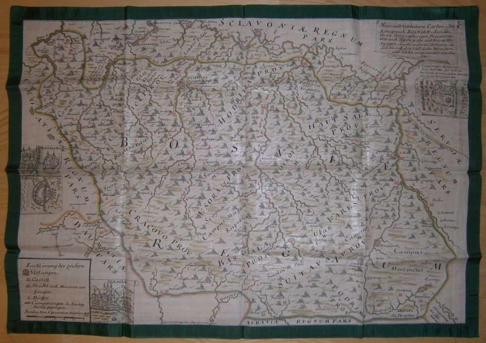
Neue und Vollkom[m]ene Carten, des Königreich Bosnien, Sambt ihren darzugehörigen Provincien. Wie auch dessen Grosse und Kleine Vestungen, Sambt anderen Örthern, So Sich bis auff das 1737te Jahr befinden und Solche angemercket worden Seyn.
1740: By Johannes Weingartner. Manuscript, colored military map of Bosnia on linen with green silk edges, by Johannes Weingartner. 660 × 470 mm; 620 × 430 mm. In fine condition.
Showing the borders and the fronts of the Habsburg Empire in Dalmatia and the Ottoman Empire in Bosnia on the day of the battle of Banja Luka, August 4, 1737. It was one of the main battles of the Russo-Turkish(-Austro) War (1735–1739) in which the Ottomans led by, Hekimoğlu Ali Pasha (1689–1758) grand vizier, defeated the Austrians, who entered the war a month before in July, 1737.
With four vignettes of views of principal cities: Banja Luka, Bihać, Sarajevo (written “Seraglio” on the map, which is equivalent to “saray” or “serail” which means the governor’s palace in Turkish) and Zvornik.
.
Price: €3,000.00