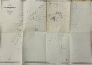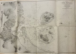
Approaches to Port Victoria, Indian Ocean, Seychelles, Mahé Island / surveyed by Commander A. F. Balfour, Assisted by Lieut.ts C. H. Simpson, W. V. S. Howard & H. C. Lockyer, H. M. Surveying Ship Stork, 1890. [British Admiralty hydrographic charts of the world, 722.]
London: Published at the Admiralty, under the Superintendence of Captain W. J. L. Wharton, R. N : F. R. S : Hydrographer, Sold by J. D. Potter […] (Engraved by Davies & Company), 16th May 1892. First edition. Engraved map. Scale 1:12,093 (E 55°29'/S 4°37’). Size: ca. 100 × 70..... More